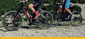
The mountain biking space VTT-FFC around Mont Ventoux offers 220 kms of marked trails.
Created by professionals, these trails will lead you from Ventoux's slopes and woody foothills to the steep mountainous area of the Monts de Vaucluse, passing through the wide open spaces of Pays de Sault.
Whether you are an expert or a beginner, enjoy your trip !
Circuits
- 1. Les Baux Départ - Start : Bédoin, Camping Municipal Distance : 14 km Dénivelé - Altitude change : + 270 m
- 2. Pavillon Rolland Départ - Start : Bédoin, Camping Municipal Distance : 23 km Dénivelé - Altitude change : + 650 m
- 3. Chalet Reynard Départ - Start : Bédoin, Chalet Reynard Distance : 12,5 km Dénivelé - Altitude change : + 400 m
- 4. Le Rat Départ - Start : Bédoin, Camping Municipal Distance : 40 km Dénivelé - Altitude change : + 1100 m Ce parcours est le plus difficile et le
- 5. Enduro du Ventoux face sud Départ - Start : Bédoin, Col des Tempêtes ou Chalet Reynard Distance : 25 km Dénivelé - Altitude change : - 1600 m Au départ du col des Tempêtes (1841
- 6. Enduro du Ventoux face nord Départ - Start : Station du Mont Serein (Beaumont-du-Ventoux) Distance : 13 km Dénivelé - Altitude change : - 1150 m Au départ de la station du Mont-Serein
- 7. Le Bois du Défends Départ - Start : Sault, Parking des Aires Distance : 10,5 km Dénivelé - Altitude change : + 100 m
- 8. Terre de lavande Départ - Start : Sault, Parking des Aires Distance : 25 km Dénivelé - Altitude change : + 420 m
- 9. De Sault à Brouville Départ - Start : Sault, Parking des Aires Distance : 24 km Dénivelé - Altitude change : + 500 m
- 10. À la découverte des collines pernoises Départ - Start : Pernes-les-Fontaines, Complexe sportif Distance : 10,5 km Dénivelé - Altitude change : + 100 m Parcours d’initiation, idéal en famille
- 11. Les contreforts des Monts de Vaucluse à Pernes-les-Fontaines Départ - Start : Pernes-les-Fontaines, Complexe sportif Distance : 21 km Dénivelé - Altitude change : + 420 m
- 12. De Monieux à Saint-Jean-de-Sault Départ - Start : Monieux, parking le long de la D942 Distance : 12,5 km Dénivelé - Altitude change : + 220 m
- 13. Aux portes de la Nesque Départ - Start : Villes-sur-Auzon, parking rue Villeneuve Distance 22 km Dénivelé - Altitude change + 660 m
Specific advice
The area around the summit of Ventoux is a protected site. It is forbidden to use a mountain bike off the designated marked trails, or only on the GR4 Grand Randonnée route on the south side. Thank you for staying on the trails. In the natural areas, stay on the marked trails and do not cut corners to avoid creating new tracks.
The marked mountain biking trails are not reserved solely for mountain bikers, so you may come across other trail users (hikers, horse riders, etc.). Stay in control of your speed and give them priority.
Hunting is an important activity from September to February on the Massif du Ventoux and the Monts de Vaucluse. During this period, wear brightly coloured clothing, make your presence known and respect the signs put up by hunters.
Agricultural activity can be found on Ventoux: respect the animals and use customary caution regarding guard dogs.