Climbing the Ventoux on foot is a challenge that can become your reality! Here we give you the keys to successful climbs. Different hikes for all levels!
Climb on foot from chalet Reynard to the top
2hrs one way / 2hrs return (4h30 return) - 5,3 km
Altitude of Start altitude: 1420 meters - 550 meters difference in level of altitude.
The departure is on the right of the chalet Reynard by the path towards the crests (signposted "Mont Ventoux"). Follow the combe that goes directly up to the ridge. But the climb is not easy. Endurance and regularity are required.
Once you have passed the 200 metres difference in altitude, you are on the ridge! Take the GR4 on the left at the post "Le Signal". The path is very pleasant with a magnificent panorama and the view of the Ventoux tower waiting for us in the distance. The vegetation changes as you walk, leaving the small trees and shrubs for increasingly rocky landscapes.
The path is not particularly difficult for several kilometres until you reach the col des tempêtes, where the last few metres increase the difference in height. Two beautiful climbs await you, but they are not long and you will often stop to admire the landscape on both sides of the slope. The Southern Alps, the Toulourenc valley to the north, and on the other side the Comtat plain, the Alpilles and the Cevennes will amaze you!
The effort of climbing will be quickly forgotten when you reach the top!
Suggestions for the descent : 8.5 km (+29m; -491 m) Duration: 2h30
Join the Sainte Croix chapel and follow the yellow markers that go down (south side) to the Jas des Pèlerins. At the Jas, there are 2 possibilities:
1) before the Jas, follow the yellow signposted path on the left which winds halfway down the slope between the D974 and the forest track which it joins after the Jas de la Fréchière. Follow the track on the left which takes you back to the D974, 300m before the Chalet Reynard.
2) Go past the Jas, and turn left onto the forest track (cross-country skiing track in winter) which takes you back to the D974, 300m before the Chalet Reynard.
Follow the itinerary on https://ignrando.fr/fr/parcours/fiche/details/id/1805887
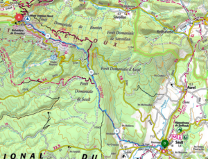
Climb on foot to the Ventoux from Sault
Sporty ascent!
17,6km/+ 1235 m/- 117 m
Parking Place des Aires at the top of the village of Sault. Go past the Tourist Office and turn left (hairpin) onto the D137. In the second hairpin, take the stone path that goes down to the right of the EDF relay station, below the road. At the road, follow the yellow signs to the right until you see the yellow sign "La Coustiero", then turn left towards La Loge. At the road, turn right and follow the GR/GRP signs towards Verdolier.
The warm-up is over and the serious business begins with the climb to Jas Forest (+387m in 2.2km)! The climb becomes steadier and then gets harder again from the Baraque d'Aurel. Be careful, at the Baraque d'Aurel, cross the forest road and follow the GR4 which rises opposite, towards the Pas de la Frache. The GR4 takes you up to the ridges that you follow with the summit in view, and extraordinary views towards the Alps, the Monts d'Ardèche, the meanders of the Rhône or the Luberon massif.
Climb on foot from Bédoin (hamlet Sainte Colombe) to Mont Ventoux
4h30 to 5h (one way) - 10,6 km - altitude difference + 1463 m
By car from Bédoin, follow the route du Ventoux (D974) to the hamlet of Sainte Colombe, then park on the right (car park).
Opposite the car park, take the road that goes to the cemetery (PR markings = yellow). After the cemetery, turn right to join a forest track (marked GR).
Turn left for 230m to reach a yellow signpost indicating the Combe d'Ansis path. Follow this yellow signposted path up through a forest of cedars, holm oaks and hardwoods, with the remains of sheepfolds and rock shelters... quite an atmosphere!
Go up the Combe d'Ansis then the Combe Fiole (between altitudes 524 and 1918...) until you reach a forest track. At the track, turn left and enjoy 300 metres of flat land until you reach the Jas des Pèlerins.
At the Jas, go up to the right along the yellow marked path which quickly leaves the forest and climbs to the Chapelle Sainte Croix through the summit scree.
At the chapel, the summit dominates you! Only a few dozen metres after this great effort to enjoy the breathtaking panorama!
Climb on foot from Mont-Serein to the summit by the GR4
1h50 one way / 4.3 km
Starting altitude: 1413 m - 490 m difference in altitude
Go to the end of the station where the campsite is located to park.
Go through the barrier on the right of the campsite; follow the tarmac track to the crossroads indicating the GR4 and GR9 on the right (white and red markings). Follow the GR4 to the top of the Ventoux.
You will start to climb to the signpost "Mont Ventoux" (3,5 km). The access is easy, the slope is not too steep.
The landscapes open up and you will walk through the woods for several kilometres, which will make your ascent very pleasant, with the good smell of pine trees and aromatic plants. Stop for a photo at the Combe fiole, but don't go too far ahead as it is deep and unstable.
Enjoy the scenery and look out for the chamois that love this area.
Return to the path towards the summit, the forest continues. The Mont Ventoux becomes more and more mineral and it is here that the path really starts to climb. The last few switchbacks are the most difficult, but you will get there if you take your time!
Suggested descent: Pass the summit and go right (west) to descend towards the Chapelle Sainte Croix; follow the small stone path on the right that joins the road (north side); follow it for 850m to recover the GR4 in the bend and follow it to the station.
Climb on foot from Malaucène (hamlet Les Alazards) to the top
5h15 One way 12 km
Starting altitude: 597 m - 1313 m difference in altitude
By car from Malaucène, follow the route du Ventoux, then very quickly turn left onto the D153 (passing by the Spa Ventoux Provence) to reach the hamlet of Valettes in the commune of Beaumont-du-Ventoux. Continue straight on until there is no more road! This is your "end of the world" for the start of this hike, indicated by a car park. You start your ascent at the Le Plan sign at 597 m altitude.
You start climbing at the signpost (follow the GR4). Find your own rhythm, but the effort will not be too long. Your eyes will be drawn to the valley below with its vineyards and orchards, which you will see several times as you follow the intertwined paths between the thick forests.
The effort starts again just before you reach the Col du Comte sign. After a break, you take the path opposite (still the GR4). The forest thickens, the path is pleasant and without too much difficulty.
You arrive on the track, but you only cross it to stay on the GR. The forest gradually gets further away.
On your left a large scree appears. And for your greatest happiness, you are going to cross it! You may be dazzled by the whiteness of the stones! At the intersection, don't take the track on the right that leads to the sports chalet, but go up a few metres on the left to quickly join the path that leads to the "Contrat" on the right. By this forest path, you will arrive directly at the Mont-Serein campsite.
You know the rest, it's the ascent from the campsite to the summit (already mentioned, earlier on this page!).