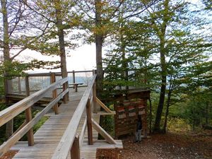
The Durefort Tower in St Jean de Sault
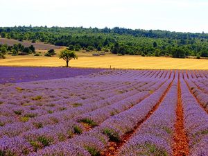
La Tour de Durefort, Sault
Start/Finish in the hamlet of St Jean de Sault – Circular walk of 8,5 km (5,28 miles) – Length 2 hours and 50 mins – Difficulty : Medium – Ascent +/- 250 m (820 feet).
This walk offers, be it after a certain effort, breathtaking views of the Mont Ventoux, the Albion plateau and the Sault valley. Beautiful year round but particularly in the summer when the lavender is in bloom…The walk begins in the hamlet of St Jean de Sault, passing through a peaceful valley to arrive up on a plateau at 1000m (3281 feet) of altitude where lavender and cereal crops grow alongside one another.
Download the details here, pdf, 2.71mo
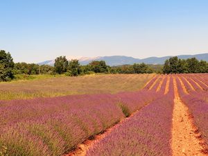
Le Chemin des Lavandes – The Lavender Trail – Sault
Start/Finish : Sault - 3 possible start points : one in front of the Tourist Office (length 12,1 km/7,52 miles), one at the car park of the Défends hippodrome (8,4 km/5,22 miles) and one from the car park of the ‘Chemin des Lavandes’ (5 km/3,11 miles) – Difficulty : Easy – Gradients : -124/+143 m (-407/469 feet).
Discover this themed trail in Sault dedicated to the famous lavender, emblem of the Albion plateau and of Provence. Spectacular colours to be seen during the flowering period (July usually).
See and download on Terra Rando
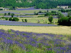
The Défends Woods in Sault

Bois du Deffends, Sault
Start/Finish : 2 possible start points : one in front of the Tourist Office and one from the Hippodrome car park at the Défends - Distance : 6,7 km (4,16 miles)/9,4 km (5,84 miles) – Length : Approx 2 hours 20 mins – Difficulty : Easy – Ascent : 115 m (377,3 feet).
This walk at 766 m/2513 feet in altitude is pleasant year round, particularly in the summer in the cool shade of the oak trees. Discover the field of lavandin (hybrid lavender) in the centre of the hippodrome and stop for a picnic at one of the nearby tables.
See and download the trail on Terra-rando Bois du Défends à Sault
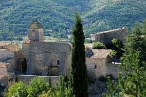
Walk – 3 Villages : Sault, Aurel and Saint Trinit

Saint-Trinit
Start/Finish : Place des Aires in Sault but also possible to start in Aurel or Saint Trinit depending on where you are based. Circular walk – Length : 4 hours- Distance : 16 km/ 9,94 miles – Difficulty : Medium – Ascent : 290 m/ 951 feet – VTT/Mountain bike : OK
A triangular walk that alternates between open countryside and woods. Enjoy the colours and scents of the lavender and lavandin fields in July along with the coffee stops in the villages you pass through.
See and download the route on Provence Guide
The Marquisan at Saint Trinit

Rando, Le Marquisan, Saint Trinit
Start/Finish : in front of the Mairie in Saint Trinit - Circular walk of 11,6 km/7,21 miles – Length : 3 hours and 30 mins – Difficulty : Medium – Ascent : 88m/289 feet.
A fairly easy walk through the typical landscape of the Albion plateau. Splendid views of the Mont Ventoux and the lavender fields with long paths through the Caviotte woods and its impressive 100 year old oaks. After your walk you can stop for refreshments at the Bistro de Pays in the village !
See and download the route Le Marquisan here, jpg, 6.88mo
Ferrassières – Between lavender and dry stone

Entre lavandes et pierres sèches, Ferrassières
Start/Finish: Infront of the lavender producer ‘’Ho, Bouquet de Lavandes’’ in Ferrassières. Circular walk of 4,8 km/2,98 miles – Length : 2 hours – Difficulty : Easy – Ascent : 160 m/525 feet.
An easy circular walk ideal for discovering the lavender fields and bories (dry stone shelters) for which the village is reputed.
The Botanical paths of Ferrassières
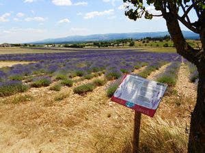
Les sentiers botaniques, Ferrassières
Start/Finish : Car park in front of the lavender producer ‘Ho! Bouquet de Lavandes’’ at Ferrassières – Circular walk – Distance : 3,3 km/2,05 miles or 4,6 km/2,86 miles – Length : 1 hour or 1 ½ hours – Difficulty : Very Easy – Ascent : 150 m/492 feet to 176 m/577 feet.
A themed walk with information panels explaining lavender farming. Wonderful fragrances in July when the lavender is in bloom. Beautiful light and fantastic views of the Mont Ventoux and Albion plateau. The shorter version is ideal for families.
See and download the route, pdf, 4.13mo
Walk – The Rabaste at Aurel
Start/Finish : Car park in front of the Mairie – Circular walk – Length : 2 ½ hours – Distance : 6,5 km/4,04 miles – Difficulty : Easy – Ascent : 200 m/656 feet.
his walk begins in a shaded valley before heading up to higher paths overlooking the Fayet Gorge. Towards the end of the route you will discover the local truffle culture, walking through an orchard of truffle oaks.
See and download Guide rando La Rabaste, pdf, 245ko
Walk - Themed Trail – Fauna of the Ventoux at Aurel – The Deer Belvedere on the Road to the Mont Ventoux (south side)
Start/Finish : Car park at the Deer Belvedere at Aurel. Access from Sault via the RD 164 direction Mont Ventoux (a large deer sculpture marks the spot !) – Circular walk (two-way) – Length : 1 hour – Distance : 2 km/1,24 miles – Difficulty : Very Easy – Ascent : 63 m/207 feet.
In the heart of the forest, and dotted with land art, a themed trail about the animals that inhabit the Ventoux massif. A very pleasant family loop recommended from spring to autumn. Accessible with all-terrain pushchairs.
See and download the route at Provence Guide
Walk – Lavender Fields – Aurel

Start/Finish : Car park in front of the Mairie in Aurel – Circular walk – Length : 4 hours – Distance : 13,6 km/8,45 miles – Difficulty : Medium – Ascent : 326 m/1070 feet.
Between the woods and the lavender, enjoy the diverse provencal countryside around the magnificent village of Aurel.
See and download the route on Chemin des Parcs
Walk – The Farm Crops of the Albion Plateau at St Christol
Start/Finish : Car park in centre of village opposite the bar du Cours – Circular walk – Length : 2 hours 45 mins – Distance : 7,3 km/4,54 miles – Ascent : 250 m/820 feet – Mountain Bike OK.
This walk will take you to the little chapel Notre Dame de Lamaron at 1100 m/3609 feet of altitude. The air is invigorating, the views breathtaking ! In July and August the flowering lavender fields are a delight to the senses…
Download the route and map, pdf, 2.24mo
The Karstic Walk at Saint-Christol d’Albion

Start/Finish : Car park in village centre opposite the bar du Cours – Circular walk – Length : 3 hours – Distance : 6,8 km/4,22 miles – Difficulty : Easy – Ascent : 200 m/656 feet
A fun and educational family walk to discover the world that exists beneath your feet and the karstic geology of the Albion plateau. Following the various information panels along the way, you will learn also about the mysterious spring in Fontaine de Vaucluse.
Download the map of the route, jpg, 340ko